The Atlantic hurricane season kicks off on June 1, and the Gulf of Mexico is already warmer than average. Even more concerning is a current of warm tropical water flowing unusually far into the Gulf for this time of year, with the power to turn tropical storms into monster hurricanes.
It’s called the Loop Current, and it’s the 800-pound gorilla of the Gulf hurricane risks.
When the Loop Current moves that far north this early in the hurricane season — especially during what’s expected to be a busy season — it could spell disaster for people along the northern Gulf Coast, from Texas to Florida.
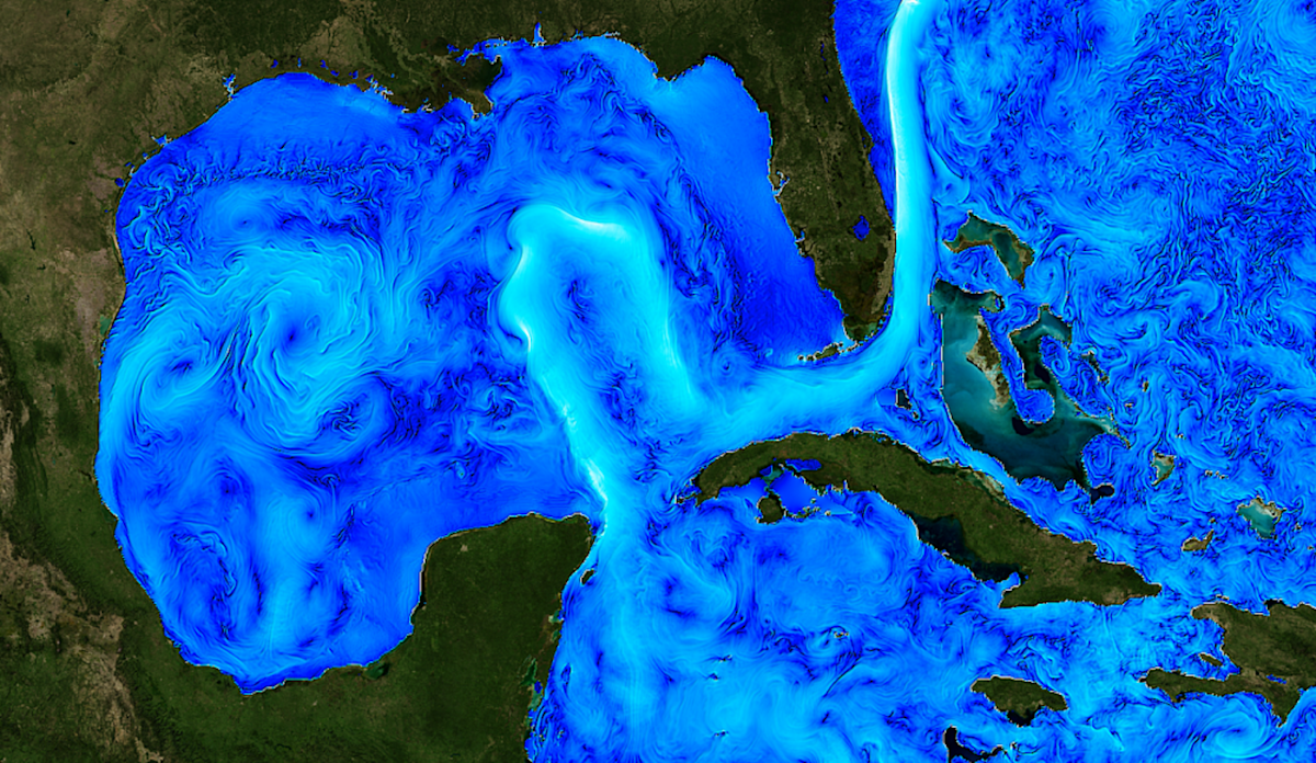
If you look at temperature maps of the Gulf of Mexico, you can easily see the Loop Current. It meanders through the Yucatan Channel between Mexico and Cuba, into the Gulf of Mexico, then winds back through the Florida Straits south of Florida as the Florida Current, where it is the main contributor to the Gulf Stream.
When a tropical storm moves across the loop current or one of its giant eddies — large rotating pools of warm water that spin away from the flow — the storm can explode in strength as it draws energy from the warm water.
This year, the Loop Current is remarkably similar to the way it did in 2005, the year Hurricane Katrina crossed the Loop Current before devastating New Orleans. Of the 27 storms listed that year, seven became major hurricanes. Wilma and Rita also crossed the Loop Current that year, becoming two of the most intense Atlantic hurricanes ever.
I have been tracking the heat content of the ocean for over 30 years as a marine scientist. The conditions I see in the Gulf in May 2022 are cause for concern. A prominent forecast foresees 19 tropical storms – 32% above average – and nine hurricanes. The loop current has the potential to charge up some of those storms.
Why the Loop Current Forecasters Worry
Warm ocean waters don’t necessarily mean more tropical storms. But once tropical storms reach waters around 26°C or warmer, they can amplify into hurricanes.
Hurricanes get most of their strength from the top 100 feet (30 meters) of the ocean. Normally, these upper ocean waters mix, allowing warm spots to cool quickly. But the Loop Current’s subtropical waters are deeper and warmer, as well as saltier, than the regular Gulf waters. These effects inhibit the mixing of the ocean and the cooling of the sea surface, allowing the warm current and its eddies to trap heat to great depths.
In mid-May 2022, satellite data showed that the Loop Current had water temperatures ranging from 78 F or warmer to about 100 meters. In the summer, that heat can extend to about 500 feet (about 150 meters).
The vortex that fueled Hurricane Ida in 2021 was over 86°F (30°C) at the surface and had heat up to about 590 feet (180 meters). With favorable atmospheric conditions, this deep heat reservoir helped the storm explode into a very powerful and dangerous Category 4 hurricane almost overnight.
Within a storm, warm ocean water can create towering plumes of rising warm, moist air, fueling high-octane hurricanes. Think about what happens when you cook a large pot of spaghetti on the stove and how the steam rises as the water gets hotter. As more moisture and heat rise in a hurricane, the pressure drops. The horizontal pressure difference from the center of the storm to the periphery then causes the wind to accelerate, making the hurricane increasingly dangerous.
Because the loop current and its vortices have so much heat, they don’t cool down significantly and the pressure will continue to drop. In 2005, Hurricane Wilma had the lowest central pressure ever in the Atlantic, and Rita and Katrina weren’t far behind.
La Niña, wind shear and other drivers of a busy season
Forecasters have other clues about how the hurricane season could be shaping up. One of these is La Niña, the climate opposite to El Niño.
During La Niña, stronger trade winds in the Pacific bring colder water to the surface, creating conditions that help push the jet stream further north. That tends to exacerbate the drought in the southern US and weaken wind shear there as well. Wind shear includes the change in wind speeds and wind directions with height. Too much wind shear can tear tropical storms apart. But less wind shear, courtesy of La Niña, and more moisture in the atmosphere could mean more hurricanes.
La Niña was unusually strong in the spring of 2022, although it is possible that it will weaken later in the year, allowing for more wind shear towards the end of the season. For now, the upper atmosphere does little that would stop a hurricane from intensifying.
It’s too early to say what will happen to the steering winds that guide tropical storms and influence where they go. Even before then, conditions over West Africa are critical to whether or not tropical storms develop in the Atlantic. Dust from the Sahara and low humidity can both reduce the likelihood of storms.
Climate change has a role
As the temperature on Earth rises, the temperature of the ocean rises. Much of the heat retained by greenhouse gases released by human activities is stored in the oceans, where it can provide additional fuel for hurricanes.
Studies suggest the Atlantic is likely to see more storms progress to major hurricanes as those temperatures rise, although overall there won’t necessarily be more storms. A study examined the 2020 hurricane season — which had a record 30 named storms, 12 of which hit the U.S. — and found that the storms produced more rain than in a world without the effects of human-induced climate change.
Another trend we’ve noticed is that the Loop Current’s warm vortices have more heat than we saw 10 to 15 years ago. Whether that has to do with global warming is not yet clear, but the impact of a warming trend could be devastating.
This article was republished from The Conversation, a nonprofit news site dedicated to sharing ideas from academic experts. It was written by: Nick Shay, University of Miami†
Read more:
Professor Lynn K. (Nick) Shay receives funding from the National Science Foundation and the National Oceanic and Atmospheric Administration. I sit on the board of directors of the Integrated Ocean Observing System Gulf of Mexico Coastal Ocean Observing System Regional Association.