However, just like in the Amazon, identifying problem areas will only get you so far if there aren’t enough resources to respond to those findings. The Nature Conservancy uses its AI model to inform conversations with land managers about potential threats to wildlife or biodiversity. Conservation enforcement in the Mojave Desert is overseen by the U.S. Bureau of Land Management, which employs only about 270 rangers and special agents.
In Northern Europe, the company Iceye started monitoring ice formation in the waters off Finland with microsatellites and machine learning. But in the past two years, the company began predicting flood damage using microwave-wavelength images that can see through clouds at any time of day. The biggest challenge right now, says Shay Strong, Iceye’s vice president of analytics, isn’t spacecraft design, data processing, or refining machine learning models that have become commonplace. It’s about institutions stuck in age-old ways of doing things.
“We can more or less understand where things are going to happen, we can get images, we can make an analysis. But the part we have the biggest challenge with right now is still working with insurance companies or governments,” she says.
“It’s that next step of local coordination and implementation that’s needed to move into action,” said Hamed Alemohammad, chief data scientist at the non-profit Radiant Earth Foundation, which uses satellite imagery to support sustainable development goals like ending poverty and hunger. to grab. “That’s where I think the industry needs to put more emphasis and effort. It’s not just about a pretty blog post and a deep learning model.”
It is often not just about getting policymakers on board. In a 2020 analysis, a cross-section of academic, government and industrial researchers highlighted the fact that the African continent has a majority of the world’s undeveloped farmland and is expected to be responsible for much of the world’s population growth in the coming years. decades . Satellite images and machine learning could reduce dependence on food imports and turn Africa into a breadbasket for the world. But, they said, lasting change requires building professional talent with technical expertise and government support so Africans can create technology to meet the needs of the continent rather than import solutions from elsewhere. “The path from satellite imagery to public policy decisions is not an easy one,” they wrote.
Labaly Toure is co-author of that article and head of the geospatial department at an agricultural university in Senegal. In that capacity and as founder of Geomatics, a company that provides automated satellite imagery solutions for farmers in West Africa, he has seen satellite imagery and machine learning help decision makers recognize how the flow of salt can affect irrigation and influence crop yields. He has also seen it help resolve questions about how long a family has been on a farm and help with land management issues.
Sometimes free satellite imagery from services like NASA’s LandSat or the European Space Agency’s Sentinel program is enough, but some projects require high-resolution photos from commercial providers, and the cost can be a challenge.
“If decision makers know” [the value] it can be easy, but if they don’t know, it’s not always easy,” Toure said.
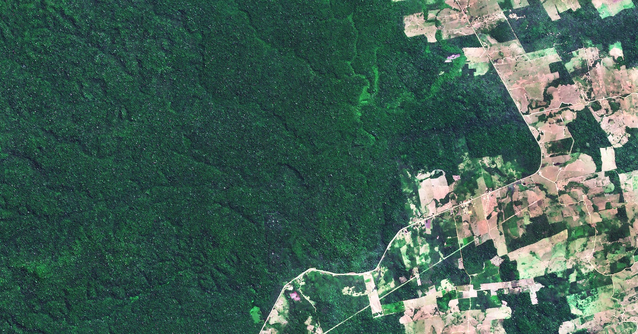
Back in Brazil, lacking federal support, Imazon is now forging ties with more state-level policymakers. “At this point, there is no evidence that the federal government will lead the way in conservation or deforestation efforts in the Amazon,” Souza said. In October 2022, Imazon signed collaboration agreements with prosecutors collecting evidence of environmental crimes in four Brazilian states on the fringes of the Amazon rainforest to share information that can help prioritize enforcement resources.
If you prosecute people who deforested protected areas, the damage is already done. Now, Imazon wants to use AI to stop deforestation before it happens, weaving that road-detection model with one designed to predict which Amazon communities are most at risk of deforestation within the next year.
Deforestation continued at a historic pace in early 2022, but Souza is hopeful that by partnering with nonprofit partners, Imazon can expand its deforestation AI to the other seven South American countries hitting the Amazon rainforest.
And Brazil will hold presidential elections this fall. The current leader in the polls, former President Luiz Inácio Lula da Silva, is expected to strengthen enforcement agencies weakened by Bolsonaro and restore the Amazon fund for foreign reforestation investments. Lula’s environmental plan isn’t expected for a few months, but environmental ministers from his previous term predict he will make reforestation a cornerstone of his platform.