The company that owns exclusive salvage rights to the Titanic shipwreck and ship artifacts filed in federal court on Saturday a map of the surrounding seafloor showing where searchers found the twisted remains of the submarine Titan.
The map, a mosaic of sonar images annotated by experts at the company, RMS Titanic Inc., shows how close the craft was to its intended destination when disaster struck.
The vehicle most likely imploded on the morning of Sunday, June 18, killing all five crew members. RMS Titanic’s director of underwater research was on the tourist submarine’s final dive as a guest of Titan’s owner, OceanGate.
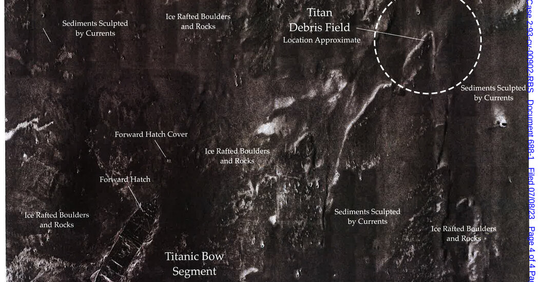
Attached to a legal application as an exhibit, the seabed map shows the ghostly outline of the Titanic’s bow section. It’s one of the wreck’s most celebrated features, as deep explorers over the decades have revealed that the fore and fore railing is relatively well-maintained, erect and almost proud in the inky darkness.
In an interview, Brian A. Wainger, an attorney for the salvage company, RMS Titanic Inc., said the map was based on private and public information available to the company. He added that he had shared the seafloor map with the United States Coast Guard, as well as the National Oceanic and Atmospheric Administration, and that neither federal agency had raised any concerns about the accuracy of the representation.
“We believe this is reliable data,” said Mr. Wainger.
In his July 8 official report, Mr. Wainger also noted that the Marine Board of Investigation, the arm of the Coast Guard investigating the disaster, will complete its investigative work in about 12 to 18 months and then hold a public hearing where witnesses will give sworn testimony.
The story of the Titanic is well known. After hitting an iceberg on its maiden voyage in 1912, the luxury liner broke in half and plunged more than two miles through the North Atlantic to its icy bottom.
The Titanic wreckage was located in 1985, and in 1994 the U.S. District Court for the Eastern District of Virginia, located in Norfolk, Virginia, granted salvage rights to RMS Titanic. As the designated salvor, defined as a person or group engaged in the recovery of a ship or lost property at sea, RMS Titanic is subject to court oversight, which has long overseen shipwreck salvage cases.
Based in Atlanta, the company uses its salvage operations for a number of purposes, including setting up touring exhibits of Titanic artifacts.
The map in the company’s archives shows a large dotted circle, labeled “Titan Debris Field,” in an area on the right or starboard side of the Titanic’s intact bow section. The map does not provide any other details, such as the size of the field. However, the map does mention the approximate location. When the Coast Guard announced on June 22 that the Titan submarine had suffered a catastrophic implosion, the Coast Guard said the debris field was about 500 yards from the Titanic’s bow.
Jessica Sanders, president of RMS Titanic, said the seabed map was included in the legal filing as part of the company’s obligation to keep the court informed of its activities and, in this case, how things are going in the hours and hours had participated in the Titan investigation. days after the submarine disappeared.
“We tried to help,” she said in an interview. “We gave them this map” so that researchers can better understand the features of the seafloor around Titanic and thus have a better chance of separating information about rocks and natural outcrops from possible evidence of the craft itself or its remains.
Ms Sanders said the map was developed in part by her employee who died in the Titan disaster: Paul-Henri Nargeolet, 77, a French submarine expert and a global authority on the Titanic, who was attempting his 38th dive to the wreck. “So part of it belonged to him,” she said, referring to the card. She added that a memorial service for Mr Nargeolet will be held in Paris next week.
Rob McCallum, the founder of EYOS Expeditions, who led seven voyages to the sunken liner, said the map showed no unexpected features or clues. “Nothing unusual stands out,” he said in an interview. The Titan submarine wreckage, he added, “is essentially where it should have been.”