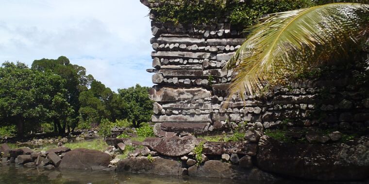
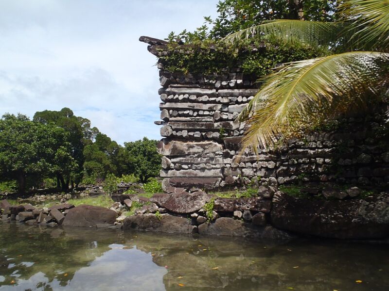
Even by the standards of enigmatic ancient ruins, Nan Madol is strange. Built primarily of “logs” made of volcanic rock, the site consists of dozens of small man-made islands separated by channels that are submerged by the tides. It is built on the shores of the Micronesian island of Pohnpei, which has an enigmatic history and remained seemingly uninhabited when islands to the north and south were inhabited during the Polynesian expansion.
Now a team of researchers offers a single explanation responsible for many of these oddities: Pohnpei Island is slowly sinking, suggesting an earlier settlement beneath the waves. And if their subsidence estimate is correct, Nan Madol would have been above the waves at the time of its construction.
Ups and downs
Human expansion into the scattered islands of the Pacific Ocean began more than 3,000 years ago and took place mainly on two parallel routes north and south of the equator. The southern route was populated by the ancestors of the Polynesians, while the northern route came from people who probably originated in the Philippines. There were islands between the two along the equator, but they were not inhabited until about a thousand years later when the descendants of the first wave expanded from the islands they had initially populated.
One explanation for this is changes in sea level. Many of the islands between the northern and southern extensions are low-lying atolls, which could have been completely submerged at the time. That’s because sea levels in the equatorial Pacific Ocean were higher as Earth’s crust adapted to redistribute water away from the massive ice sheets of the last Ice Age. In this view, ocean levels in this region gradually dropped, exposing more of these atolls and making them easier to settle.
However, that does not explain everything. The islands of Pohnpei and Kosrae are in the region, and they are both centered on volcanic peaks that would have stretched well above sea level all along. Yet there is no evidence that they settled earlier than other islands in this region. About 3,000 years after their settlement, a new culture arrived and built substantial urban centers: Nan Madol on Pohnpei and Leluh on Kosrae.
Both sites have a similar construction. Large basalt columns, such as those on the Devil’s Causeway or Devils Tower, are arranged a bit like the logs on a log cabin. Blocks of coral are also used. While Leluh was built on a small island off the coast of Kosrae, Nan Madol sits in the water, with buildings separated by canals, earning it the nickname Venice of the Pacific. While the materials and architecture are similar and shared with other Pacific sites, the channels are unique to Nan Madol.
Rising tides
The new work began with a look at sediments formed in mangrove swamps. Mangroves only grow within a limited range relative to the area’s high tide mark and will retain sediment in that area. When the tides are stable, this limits sediment formation to a range of less than a meter around the high tide mark. However, when working with sediments on these islands, the research team found mangrove sediments up to six meters thick in areas around the islands. This means that the islands are steadily sinking, allowing sediments to accumulate on top of previous layers.
Tracking these sediments in multiple locations, combined with radiocarbon dating of materials in the sediment, allowed the researchers to reconstruct sea level over the past 5,000 years or so. This shows that the islands probably subsided for most of that period. So while sea levels in the area may have dropped for part of the period, local sea levels actually rose as the islands slowly slid into the sea. A GPS station on Leluh indicates that subsidence has continued to date.
(The drop may be related to the fact that these islands are the product of hotspot volcanism, driven by a plume of hot material in the mantle. But the Pacific plate has now moved so that the hotspot is no longer under these two islands. . )
Overall, the researchers conclude that the two islands could have been inhabited during the initial expansion into the Pacific. But if people stayed on the coast like on many other islands, the remains of the first settlements would now be under water. Humans would no doubt move further inland for things like farming, but these activities may have left nothing that would survive as an artifact.
As for Nan Madol, sea level reconstruction suggests they were about a meter lower when construction began. This would have left the “canals” completely dry, except during extremely high water. Except during storm surges, the worst of the flooding would have been just a few inches. Even several hundred years later, when the rulers who built Nan Madol were driven out and the site abandoned, the canals would have dried up at low tide. So they should probably not be considered channels at all.
PNAS2022. DOI: 10.1073/pnas.2210863119 (About DOIs).