The melting of one of North America’s largest ice fields has accelerated and could soon reach an irreversible tipping point. That’s the conclusion of new research colleagues and I who have published on the Juneau Icefield, which straddles the Alaska-Canada border near Alaska’s capital, Juneau.
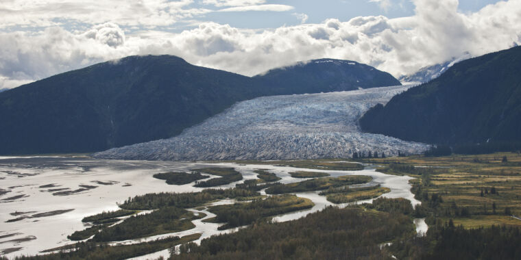
In the summer of 2022, I skied across the flat, smooth, white plateau of the ice field, accompanied by other researchers, sliding in the tracks of the person in front of me under a hot sun. From that plateau, about 40 huge, interconnected glaciers descend to the sea, with hundreds of smaller glaciers on the mountaintops around them.
Our work, now published in Nature Communications, has shown that Juneau is an example of a climate “feedback” in action: as temperatures rise, less and less snow remains in the summer (technically, the “end-of-summer snow line” rises). This in turn leads to ice being exposed to sunlight and higher temperatures, meaning more melt, less snow, and so on.
Like many Alaskan glaciers, Juneau's are top-heavy, with much ice and snow at high elevations above the late summer snowline. This previously supported the lower glacier tongues. But when the late summer snowline creeps up to the upper plateau, much of a top-heavy glacier is suddenly exposed to meltwater once again.
That’s what’s happening now, every summer, and the glaciers are melting much faster than before, thinning the ice sheet and lowering the plateau. Once a threshold is passed, these feedbacks can accelerate the melting, causing a self-sustaining loss of snow and ice that would continue even if the world stopped warming.
The ice is melting faster than ever
Using satellites, photographs, and ancient rock piles, we were able to measure the rate of ice loss across the Juneau Ice Field from the end of the last “Little Ice Age” (about 250 years ago) to the present. We found that the glaciers began to shrink after that cold period ended around 1770. This ice loss remained steady until about 1979, when it accelerated. It accelerated again in 2010, doubling its previous rate. Glaciers there shrank five times faster between 2015 and 2019 than they did between 1979 and 1990.
Our data shows that as snow cover decreases and the summer melt season extends, the ice field becomes darker. Fresh, white snow is highly reflective, and much of that strong solar energy we experienced in the summer of 2022 is reflected back to space. But the late summer snow line is rising and now often occurs on the Juneau Icefield plateau, which means that older snow and glacier ice are exposed to the sun. These slightly darker surfaces absorb more energy, causing more melting of the snow and ice.
As the ice field plateau thins, ice and snow reserves at higher altitudes are lost and the surface of the plateau sinks. This makes it increasingly difficult for the ice field to stabilize or even recover. This is because warmer air at low altitudes continues to melt, leading to an irreversible tipping point.
Long-term data like this are crucial to understanding how glaciers behave, and the processes and tipping points that exist within individual glaciers. These complex processes make it difficult to predict how a glacier will behave in the future.
The world's hardest jigsaw puzzle
We used satellite data to reconstruct how big the glacier was and how it behaved, but that really limits us to the last 50 years. To go back further, we need different methods. To go back 250 years, we mapped the moraine ridges, big piles of debris that were deposited at the glacier's nose, and places where glaciers had scoured and polished the bedrock.
To check and refine our map, we spent two weeks on the icefield itself and two weeks in the rainforest below. We camped among the moraine ridges, hung our food high in the air to protect it from bears, shouted to warn the moose and bears as we roamed the rainforest, and fought mosquitoes that were thirsty for our blood.
We used aerial photographs to reconstruct the ice field in the 1940s and 1970s, an era before satellite imagery was readily available. These are high-quality photos, but they were taken before GPS systems made it easy to find exactly where they were taken.
A few also had some minor damage in the intervening years – some tape, a tear, a thumbprint. As a result, the individual images had to be stitched together to create a 3D image of the entire ice field. It was all a bit like doing the world's most difficult jigsaw puzzle.
This kind of work is crucial because the world’s glaciers are melting rapidly. Together, they are currently losing more mass than the ice sheets of Greenland and Antarctica. Moreover, the rate at which these glaciers are thinning globally has doubled in the past two decades.
Our longer time series shows how strong this acceleration is. Understanding how and where “feedbacks” are causing glaciers to melt even faster is essential for making better predictions about future changes in this important region.![]()
Bethan Davies, Senior Lecturer in Physical Geography, Newcastle University. This article is republished from The Conversation under a Creative Commons license. Read the original article.