Fall is in full swing, but it's not too early to start looking ahead to winter, especially one that can feel significantly different than last year's, dominated by El Niño.
A weak La Niña is expected to develop ahead of the season, affecting temperatures, precipitation, and by extension, even snow across the United States.
La Niña is a natural climate pattern that affects global weather, characterized by cooler-than-average ocean temperatures in the equatorial Pacific Ocean. The effects on weather are most pronounced during the winter months in the Northern Hemisphere and have a much weaker influence in summer.
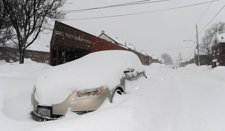
Last winter was the warmest on record for the Lower 48, as it was dominated by La Niña's counterpart El Niño, in a world that was also warming due to fossil fuel pollution.
The prolonged warmth prevented much heavy snowfall in the Northeast and Midwest and caused a winter snow drought measured in yards of missing snow.
La Niña has not arrived yet, but has a 60% chance of appearing in November, according to the Climate Prediction Center. Once it arrives, it will stick around all winter and will likely persist until at least early spring of next year.
La Niña or El Niño are never the only factors affecting the weather in a particular season or in a particular location, but they are emphasized because they tend to have an outsized effect on winter weather in the US – especially when they are strong are.
While it is still unclear how strong La Niña will become, current forecasts point to a weaker one.
The strength of La Niña matters: The stronger it is, the more of a “consistent” impact it can have on the weather, said Emily Becker, an atmospheric scientist at the University of Miami.
“A weaker event makes it more likely that other weather and climate phenomena could play a spoiler role,” Becker wrote in NOAA's latest La Niña/El Niño blog.
Previous predictions from the Climate Prediction Center show many features of typical La Niña winters. That outlook could change when the center releases its latest forecast Thursday, based on trends toward a weaker La Niña.
What could this winter look like?
No two La Niña winters are the same, but many have temperature and precipitation trends in common.
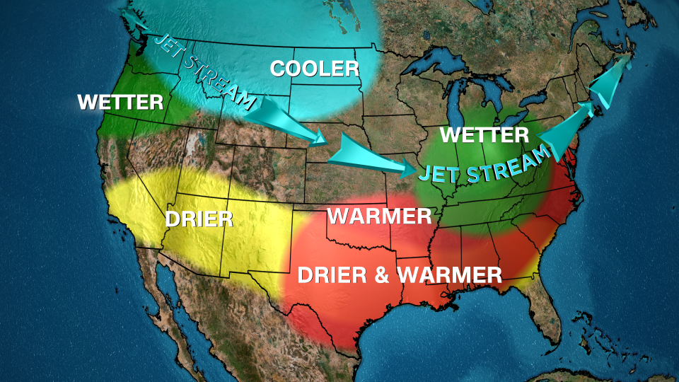
This is due to the behavior of the jet stream – essentially a river of air through which storms flow – which often shifts north during a La Niña winter. This typically shifts stormy weather from the south to parts of the northern US.
That's almost exactly what the Climate Prediction Center's latest winter forecast for December through February shows.
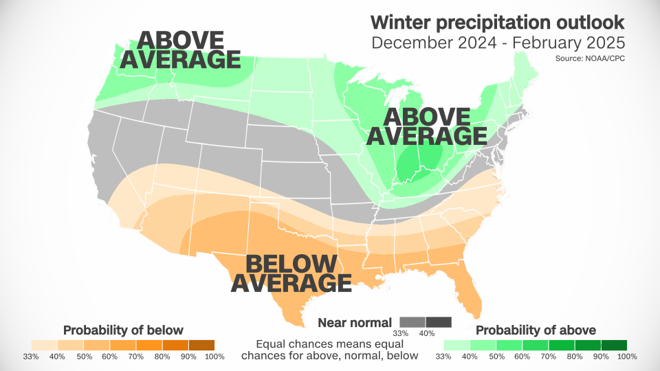
The entire northern U.S. is expected to be wetter than normal this winter, especially the Pacific Northwest, Midwest and parts of the interior Northeast. Wet weather will be critical to combating ongoing drought and drought conditions in the Midwest.
It's a complete reversal from last winter's pattern, which favored a wetter south and drier north.
More precipitation than normal does not guarantee that more snow will fall. Temperatures should still be cold enough both above and on the surface for the snow to fall and stick to the ground.
Weak La Niña events typically bring more snow to the Northeast, while snow is more limited during stronger La Niñas as warmer temperatures often creep further up the East Coast.
If this year's La Niña turns out to be quite weak, this outlook could change. Still, the latest winter temperature forecasts from downtown aren't ideal for snow lovers in the Northeast.
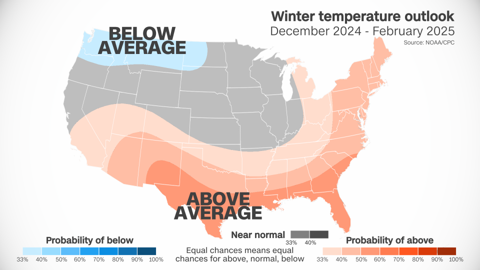
The season is expected to be warmer than normal across almost the entire southern half of the US and much of the East. This could mean some winter storms in parts of the East will become wetter instead of snowier. But because conditions in the south are drier and warmer than normal, drought conditions may worsen throughout the season.
Parts of the Midwest, the Plains and the Rockies could see temperatures closer to normal this winter, while cooler-than-normal conditions are expected from the Pacific Northwest to parts of the Dakotas.
The combination of wetter and cooler than normal conditions could potentially mean more snow for the Pacific Northwest, an area where a significant snowpack is crucial for winter tourism and water supplies for the warmer months.
Northern California is typically wetter during a La Niña winter, but the Climate Prediction Center forecast keeps the region near normal this season. La Niña was related to the extremely wet winter that much of the state endured from December 2022 to February 2023, and the wet winter before that.
Southern California is expected to be drier and warmer than average – typical of La Niña. It is crucial that the region receives a period of soaking rain in the coming months; wet weather is needed to end wildfire season. Without enough rain, fires could continue to burn due to the abundance of fire fuels such as grasses and brush available this year.
For more CNN news and newsletters, create an account at CNN.com