A tropical system — now known as Invest 91L — gaining strength near the Yucatan Peninsula could become the first tropical storm of the 2022 Atlantic hurricane season as it heads toward Florida, according to the National Hurricane Center.
If sustained winds pick up to 39 mph, it would become Tropical Storm Alex, the first name on this year’s list of storm names for the Atlantic basin.
The system will “probably” become a tropical depression or tropical storm if it moves northeast over the Caribbean Sea and the Gulf of Mexico the next day or two.
Tropical storm watch or warnings may be issued for some areas later in the day, the Hurricane Center said.
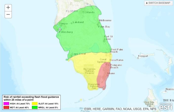
Regardless of development, the system could cause flooding in South Florida, with 8 to 12 inches of rain falling in some areas. AccuWeather forecasters predict up to 20 inches in some areas.
Follow all active storms
Forecast of too much rain
Hurricane season 2022: CSU, AccuWeather forecasters agree: Active hurricane season ahead. This is what you need to know
WeatherTiger: Potential for low-end tropical storm to kick off hurricane season this weekend
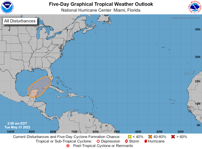
Here’s the latest update from the NHC as of June 2:
Tropical storm Alex, tropical depression has high chance of developing
-
Chance of formation up to 48 hours: high, 80 percent.
-
Chance of formation up to 5 days: high, 80 percent.
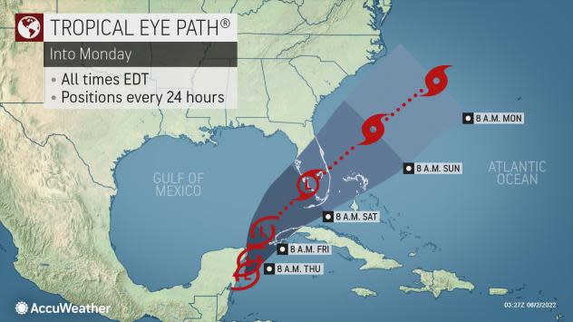
Right now, AccuWeather meteorologists expect Friday’s tropical rain to turn into a tropical depression over the southeastern Gulf of Mexico, before reaching the Florida Keys and southern Florida Friday evening and Saturday.
The system is likely to become a tropical storm as it crosses Florida or perhaps just east of Florida.
There is a chance that if wind shear decreases rapidly, there could be a faster rise to a tropical storm, perhaps before the system reaches Florida.
What could be the impact of the tropical system on Florida?
The nascent storm is expected to cut across Florida with torrential rains and building seas and produce rough surf across the region.
Regardless of the development, there will likely be areas of heavy rainfall the following day over parts of the Yucatan Peninsula and western Cuba, spreading across southern and central Florida and the Florida Keys on Friday and Friday evenings, and the northwestern Bahamas on Friday and Friday evenings. Saturday.
First mentioned storm of 2022 season† Hurricane Agatha makes landfall in southern Mexico; storm could develop again in the Atlantic Ocean
This heavy rainfall can cause widespread to numerous flash floods in South Florida and the Florida Keys.
When Can the Tropical System Affect Florida?
As the storm moves northeast, according to AccuWeather, flooding rains will begin to hit South Florida as early as Friday.
As the storm moves into Florida, it will carry a large swath of torrential rain from the Keys to the southern and central parts of the state. The heaviest rain is likely to fall in South Florida Friday through Saturday evening, with AccuWeather Local forecasting StormMax™ up to 20 inches.
Whether the system becomes a tropical depression or a tropical storm, it will approach Florida from Friday to Saturday with soaking rain showers and gusty thunderstorms.
What other impact could the storm have on Florida?
“There is also the potential for a few tornadoes and waterspouts as the system traverses the Florida peninsula or passes just south of Florida,” said AccuWeather Senior Meteorologist Brett Anderson.
In addition to torrential downpours and the potential for flooding in the city, construction seas and surf will develop around southern and central Florida and the northern Bahamas.
What else is there and where is it?
Showers associated with a weak surface valley about 200 miles northeast of the northwestern Bahamas have eased and top-level winds remain strong in the area.
What is the probability that it will become a tropical storm?
Development of this system is not expected as it moves northeast at a speed of 5 to 10 mph over the southwest Atlantic Ocean in the coming days.
-
Chance of formation up to 48 hours: low, almost 0 percent.
-
Chance of formation up to 5 days: low, 10 percent.
It’s too early at this point to determine if there will be any impact to land from the system off Florida’s east coast.
Tracking the tropics in real time:
These images, which update automatically, show you activity in the tropics in real time:
Excessive rainfall for Florida
What’s out there?
What’s next?
We will continue to update our coverage of tropical weather daily. Download the app from your local site to make sure you’re always connected to the news. And check out our special subscription offers here.
This article originally appeared on Naples Daily News: Tropical System Continues to Strengthen, Florida Affects Urban Floods